
 >
>


Time management is very much important in IIT JAM. The eduncle test series for IIT JAM Mathematical Statistics helped me a lot in this portion. I am very thankful to the test series I bought from eduncle.
Nilanjan Bhowmick AIR 3, CSIR NET (Earth Science)


Mayur Anil Badhe posted an Question
March 24, 2021 • 21:31 pm
![]() 30 points
30 points
- IIT JAM
- Geology (GG)
Q23. on a survey of india toposheet mumber 53 j3, adistance of four centimeters between two points represents an actual ground distance of: (a) 1 km (c) 8 kmn b
Q23. On a Survey of India toposheet mumber 53 J3, adistance of four centimeters between two points represents an actual ground distance of: (A) 1 km (C) 8 kmn B) 2 km (D) 16 km
2 Answer(s)
Answer Now
- 3 Likes
- 2 Comments
- 0 Shares
-
![comment-profile-img]() >
>
-
![comment-profile-img]() >
>
Sajan sarthak
![best-answer]()
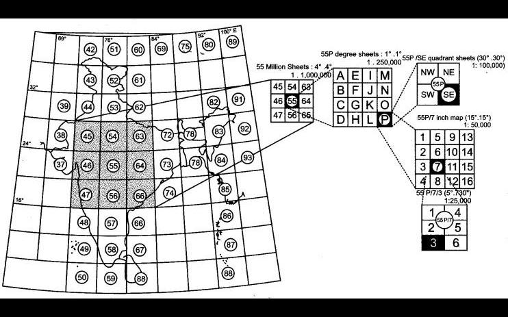
I am sharing a scale map just go through them like a question you had posted before a no like 53 denotes scale of 1:1000000 means 1 cm on map=10km on ground Number and letter 53J scale 1:250000 1cm on map = 2.5 km on ground number letter/number(1-16) scale 1:50000 called toposheet scale one cm on map = 0.5 km on ground.
![cropped8677441845651225578.jpg]()
Do You Want Better RANK in Your Exam?
Start Your Preparations with Eduncle’s FREE Study Material
- Updated Syllabus, Paper Pattern & Full Exam Details
- Sample Theory of Most Important Topic
- Model Test Paper with Detailed Solutions
- Last 5 Years Question Papers & Answers
Sign Up to Download FREE Study Material Worth Rs. 500/-


Sajan sarthak Best Answer
NOW as question says about 4 cm on map it will be definitely 0.5*4= 2km on ground. Option B is the answer. as toposheet scale is 1: 50000