
 >
>

 >
>

Time management is very much important in IIT JAM. The eduncle test series for IIT JAM Mathematical Statistics helped me a lot in this portion. I am very thankful to the test series I bought from eduncle.
Nilanjan Bhowmick AIR 3, CSIR NET (Earth Science)


- IIT JAM
- Geology (GG)
Resolution of remote sensing? variance of radiance received by remoote sensing?
2 Answer(s)
Answer Now
- 1 Likes
- 3 Comments
- 0 Shares
-
![comment-profile-img]() >
>
-
![comment-profile-img]() >
>
Rahul kumar
![best-answer]()
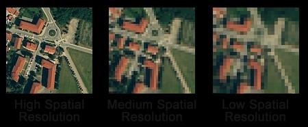
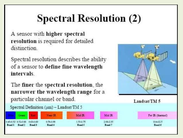
In remote sensing, we mainly deal with three types of resolution; 1. Spatial, 2. Spectral and, 3. Temporal resolution. 1. Spatial Resolution: Spatial resolution refers to the pixel size of remote sensing data. Pixel is the smallest building block of image. 2. Spectral Resolution: This resolution refers to the specific wavelength bands which can be measured by sensors. The finer the spectral resolution, the narrower the wavelength range for a particular channel or band. 3. Temporal resolution: This resolution refers to the time Interval between two images shot from same area. Radiance in remote sensing refers the received energy from the target area. There will be significant variation in radiance received by remote sensing instruments depending on parameters like presence or absence of clouds, type of topography, material types etc.
-
![comment-profile-img]() >
>
Sajan sarthak Best Answer
The resolution of an image refers to the potential detail provided by the imagery. In remote sensing we refer to three types of resolution: spatial, spectral and temporal. Spatial Resolution refers to the size of the smallest feature that can be detected by a satellite sensor or displayed in a satellite image. variance resamples a raster input layer (normally a remotely sensed image) to successively decreasing resolutions and calculates the mean local variance of the entire image at each resolution. Local variance is defined as the variance in a 3x3 window.
![cropped7296823382892328486.jpg]()
![cropped232802110868894200.jpg]()
![cropped5543834743625595996.jpg]()
![eduncle-logo-app]()
nice illustration
Do You Want Better RANK in Your Exam?
Start Your Preparations with Eduncle’s FREE Study Material
- Updated Syllabus, Paper Pattern & Full Exam Details
- Sample Theory of Most Important Topic
- Model Test Paper with Detailed Solutions
- Last 5 Years Question Papers & Answers
Sign Up to Download FREE Study Material Worth Rs. 500/-


Rahul kumar
In remote sensing, we mainly deal with three types of resolution; 1. Spatial, 2. Spectral and, 3. Temporal resolution. 1. Spatial Resolution: Spatial resolution refers to the pixel size of remote sensing data. Pixel is the smallest building block of image. 2. Spectral Resolution: This resolution refers to the specific wavelength bands which can be measured by sensors. The finer the spectral resolution, the narrower the wavelength range for a particular channel or band. 3. Temporal resolution: This resolution refers to the time Interval between two images shot from same area. Radiance in remote sensing refers the received energy from the target area. There will be significant variation in radiance received by remote sensing instruments depending on parameters like presence or absence of clouds, type of topography, material types etc.