
 >
>

 >
>

Time management is very much important in IIT JAM. The eduncle test series for IIT JAM Mathematical Statistics helped me a lot in this portion. I am very thankful to the test series I bought from eduncle.
Nilanjan Bhowmick AIR 3, CSIR NET (Earth Science)


Gurmeet Singh posted an Question
September 13, 2020 • 23:27 pm
![]() 30 points
30 points
- IIT JAM
- Geology (GG)
Sir. question in the picture.
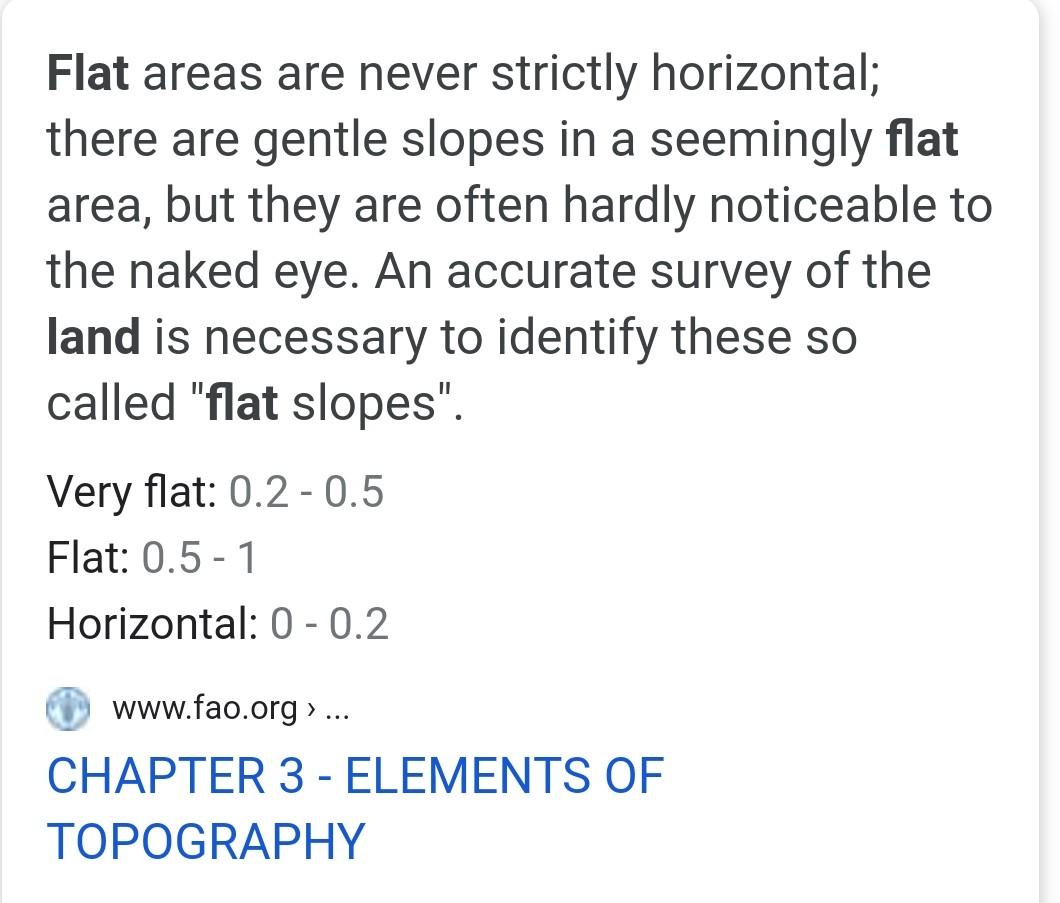
The representation of general topography of a very flat terrain is possible only By drawing contour at large interval By drawing contour at small By giving spot levels at large interval By giving spot levels to salient
3 Answer(s)
Answer Now
- 1 Likes
- 9 Comments
- 0 Shares
-
![comment-profile-img]() >
>
-
![comment-profile-img]() >
>
Rahul kumar
![best-answer]()
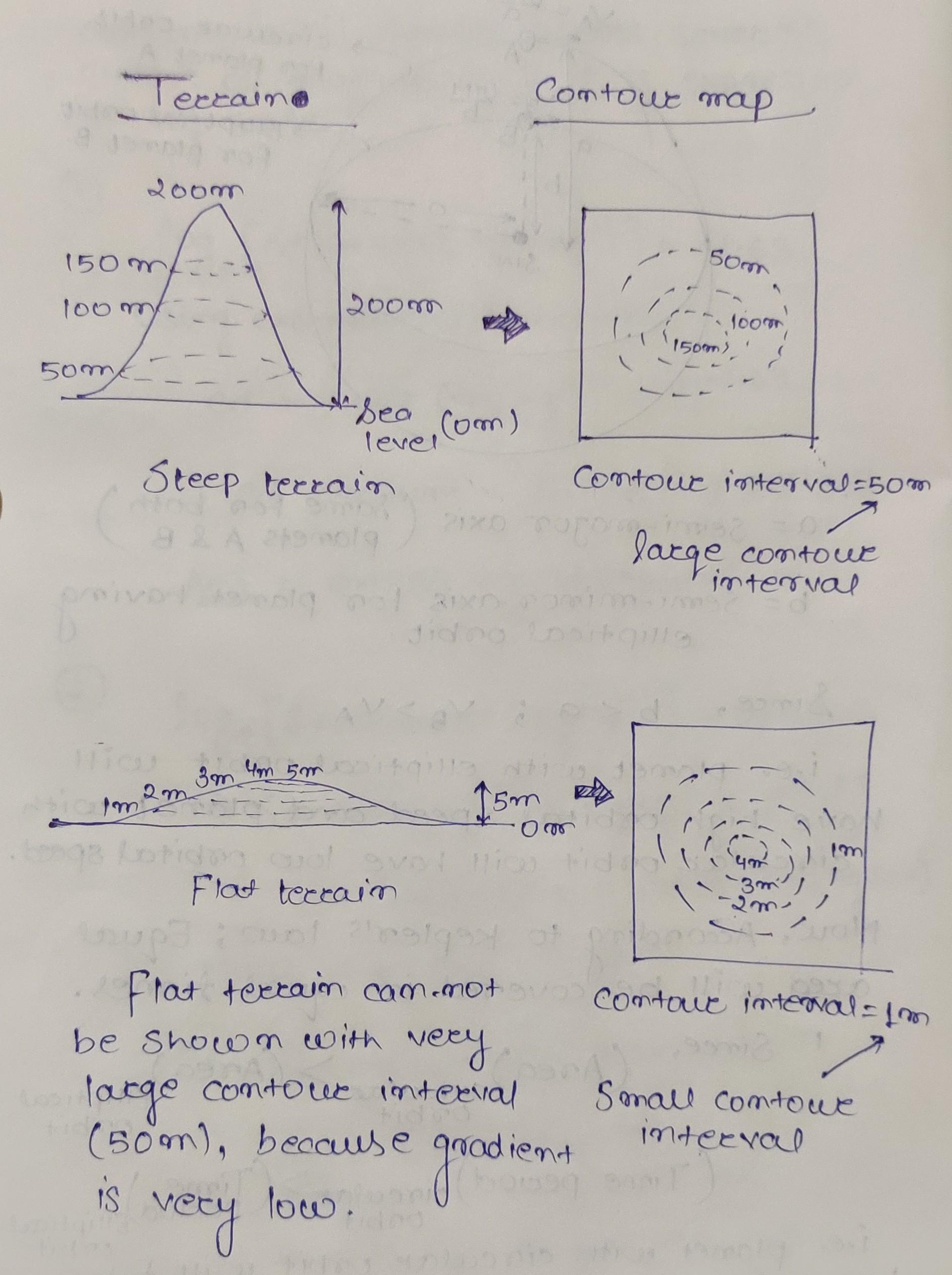
Dear student, have a look at attached figure. Flat doesn't means strictly horizontal. There is always some amount of inclination for flat terrain also. And you can draw contours with very small intervals even for low inclinations.
![cropped8900116127430899703.jpg]()
![eduncle-logo-app]()
but sir it is clearly mentioned as flat ...the logic you are giving to know whether anything is flat or not flat in true scene. we can't assume that
-
Sashi
good question gurmeet
-
![comment-profile-img]() >
>
Sajan sarthak
Dear gurmeet because we can't draw any contour on flat terrain.. we can only see some important salient features to know in map. and basic thumb. rule is that if there is no contour present we can say it's a flat terrain.
-
![comment-profile-img]() >
>
Rahul kumar
Dear Gurmeet, take a look at attached image. I have tried to explain why we should use small contour interval in flat terrain. Flat terrain doesn't mean Horizontal, there might be some undulations in flat terrain as well but the inclination (gradient) should not exceed 5 degrees. Let me know if you still have any questions. Hope this helps.
![cropped5057629094542373564.jpg]()
![eduncle-logo-app]()
but sir this is gentle slope topography in question it's given flat
![eduncle-logo-app]()
I think D will be that answer because we basically can't draw any contour there and only some important features can be seen to identify that area
![eduncle-logo-app]()
Dear student, have a look at attached figure. Flat doesn't means strictly horizontal. There is always some amount of inclination for flat terrain also. And you can draw contours with very small intervals even for low inclinations.
-
![comment-profile-img]() >
>
Rahul kumar
Feel free to ask if you have any further queries.
![eduncle-logo-app]()
sir, how its possible to draw contours of flat surface or terrain. sir can you make it something visualise so that i can imagine.
![eduncle-logo-app]()
Ok Gurmeet, I will try to explain it with diagram. Give me some time.
![eduncle-logo-app]()
Dear Gurmeet, take a look at attached image. I have tried to explain why we should use small contour interval in flat terrain. Flat terrain doesn't mean Horizontal, there might be some undulations in flat terrain as well but the inclination (gradient) should not exceed 5 degrees. Let me know if you still have any questions. Hope this helps 😊
-
![comment-profile-img]() >
>
Rahul kumar Best Answer
Yes Gurmeet, I got your point. Option D can also be a possible answer because, In flat terrain the elevation difference is very slight. So when we draw contours of this region, the salient features of the ground could not be represented. But at same time, option B is also a correct answer; small Interval contour is also used for flat terrain.
-
![comment-profile-img]() >
>
Rahul kumar
Ans (B) By drawing contour at small interval The representation of flat topography is only possible when the contour of very small intervals (few centimeters to upto one meter) are drawn on a small scale map. Since the gradient is very low in case of flat topography only contour with small interval can depict that variation.
![eduncle-logo-app]()
sorry to say sir. but i checked now. ans given is D
-
![comment-profile-img]() >
>
Sajan sarthak
![best-answer]()
D option will be the answer. Dear gurmeet because we can't draw any contour on flat terrain.. we can only see some important salient features to know in map. and basic thumb. rule is that if there is no contour present we can say it's a flat terrain.
![eduncle-logo-app]()
sir, how ?
![eduncle-logo-app]()
i didn't understand
![eduncle-logo-app]()
see the reply gurmeet
![eduncle-logo-app]()
dear gurmeet please mark as answered to my answer.
Do You Want Better RANK in Your Exam?
Start Your Preparations with Eduncle’s FREE Study Material
- Updated Syllabus, Paper Pattern & Full Exam Details
- Sample Theory of Most Important Topic
- Model Test Paper with Detailed Solutions
- Last 5 Years Question Papers & Answers
Sign Up to Download FREE Study Material Worth Rs. 500/-


Rahul kumar
Dear Gurmeet. You can ask if you still have any queries. Please mark the question as answered if you are satisfied with the Answer.
i ll do soon sir.