
 >
>
 >
>


Time management is very much important in IIT JAM. The eduncle test series for IIT JAM Mathematical Statistics helped me a lot in this portion. I am very thankful to the test series I bought from eduncle.
Nilanjan Bhowmick AIR 3, CSIR NET (Earth Science)


- IIT JAM
- Geology (GG)
Types of satellite based remote sensing with example?
2 Answer(s)
Answer Now
- 1 Likes
- 2 Comments
- 0 Shares
-
![comment-profile-img]() >
>
-
![comment-profile-img]() >
>
Rahul kumar
![best-answer]()
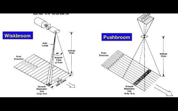
Mainly there are two types of sensor used in satellite based remote sensing. 1. Pushbroom, 2. Whiskbroom A whisk broom, also known as an across-track scanner, is a technology for obtaining satellite images with optical cameras. In whisk broom sensor, a mirror scans across the satellite’s path (ground track), reflecting light into a single detector which collects data one pixel at a time. A push broom scanner, also known as an along-track scanner, is a device for obtaining images with spectroscopic sensors. Please refer the attached figure for details.
![cropped6396212015143887442.jpg]()
Do You Want Better RANK in Your Exam?
Start Your Preparations with Eduncle’s FREE Study Material
- Updated Syllabus, Paper Pattern & Full Exam Details
- Sample Theory of Most Important Topic
- Model Test Paper with Detailed Solutions
- Last 5 Years Question Papers & Answers
Sign Up to Download FREE Study Material Worth Rs. 500/-


Sajan sarthak![best-answer]()
Satellites can be classified by their orbital geometry and timing. Three orbits commonly used for remote sensing satellites are geostationary, equatorial and Sun synchronous. A geostationary satellite has a period of rotation equal to that of Earth (24 hours) so the satellite always stays over the same location on Earth. Communications and weather satellites often use geostationary orbits with many of them located over the equator. In an equatorial orbit, a satellite circles Earth at a low inclination (the angle between the orbital plane and the equatorial plane). The Space Shuttle uses an equatorial orbit with an inclination of 57 degrees. Sun synchronous satellites have orbits with high inclination angles, passing nearly over the poles. Orbits are timed so that the satellite always passes over the equator at the same local sun time. In this way the satellites maintain the same relative position with the sun for all of its orbits. Many remote sensing satellites are Sun synchronous which ensures repeatable sun illumination conditions during specific seasons. Because a Sun synchronous orbit does not pass directly over the poles, it is not always possible to acquire data for the extreme polar regions. The frequency at which a satellite sensor can acquire data of the entire Earth depends on sensor and orbital characteristics. For most remote sensing satellites the total coverage frequency ranges from twice a day to once every 16 days.